Introduction to Mt. Rinjani: Indonesia’s Second-Highest Volcano
Perched majestically on the island of Lombok in Indonesia, Mt. Rinjani stands as a testament to the volcanic power and natural beauty that define this region. Rising to an impressive height of 3,726 meters (12,241 feet), it is Indonesia’s second-highest volcano after Mount Kerinci on Sumatra. Its imposing presence has earned it a revered status among mountaineers, nature enthusiasts, and cultural explorers alike. This active stratovolcano not only shapes the landscape of Lombok but also influences the island’s climate, ecology, and local culture, making it a vital ecological and cultural landmark.
Cradled within the expansive Gunung Rinjani National Park, Rinjani offers more than just a climbing challenge; it is a gateway into a dynamic ecosystem teeming with diverse flora and fauna. The mountain’s historical significance is deeply woven into local indigenous beliefs, with many legends attributing spiritual power to its summit. Its active status as a volcano adds layers of intrigue and caution, prompting scientific interests and adventure-seekers to explore its slopes, caldera lakes, and geothermal features. Whether ascending for adventure or studying its geological history, visitors are captivated by Rinjani’s multifaceted allure.
Historical Significance and Geological Background
Mt. Rinjani’s geological history is as fascinating as its physical grandeur. Formed over 200,000 years ago during Indonesia’s active tectonic period, it belongs to the ring of fire—a complex zone of volcanic activity that encircles the Pacific Ocean. Its stratovolcano structure comprises layers of lava, ash, and other volcanic deposits that create its formidable profile.
The volcano has experienced several eruptions in recorded history, notably intense activity between 2015 and 2016, which included ash plumes rising up to 6 km into the atmosphere and lava flows reshaping certain areas. These eruptions demonstrate both the mountain’s dynamic nature and the ongoing need for monitoring and preparedness. The volcano’s two primary craters—Segara Anak, a stunning caldera lake, and Rinjani’s main summit—are evidence of its eruptive past and geothermal activity.
Scientists study Rinjani not only to predict future eruptions but also to understand the region’s volcanic systems. The mountain’s eruptions have significantly influenced regional geology, depositing volcanic ash that fertilizes the surrounding soil, thus fostering a rich biodiversity that sustains local communities.
Location and Ecological Importance in Lombok
Located in North Lombok Regency, Mount Rinjani dominates the island’s landscape, covering approximately 41,330 hectares of the Rinjani National Park. It plays a pivotal role in maintaining the ecological balance of the region. The park’s transition zone, called Wallacea, is characterized by a unique blend of Asian and Australian flora and fauna, making it a biodiversity hotspot.
The ecological significance of Rinjani extends beyond its volcanic nature. Its lush forests, alpine meadows, and freshwater lakes create vital habitats for numerous species, many of which are endemic or endangered. The park is home to critically endangered species such as the Rinjani bull and the black ebony, along with various bird, reptile, and insect species.
The caldera lake Segara Anak, nestled within the volcano, is a vital water source supporting local agriculture and communities. Its geothermal features contribute to the region’s richness, with hot springs and fumaroles providing natural thermal energy that sustains small communities and supports eco-tourism activities.
This ecological richness emphasizes the importance of conservation efforts, especially as increasing tourism and climate change pose challenges to the delicate balance of this mountain ecosystem.
Best Time to Visit and Climate Overview
The optimal period to embark on a Rinjani trek is during the dry season, which spans from May to September. During these months, the weather is relatively stable, with minimal rainfall, clear skies, and cooler temperatures—ideal conditions for trekking. The rainy season, from October to April, often brings heavy rains, strong winds, and increased risks of landslides or hypothermia, making climbs hazardous and less enjoyable.
Climate-wise, Rinjani experiences tropical conditions. At its summit, temperatures can dip below freezing, especially during early mornings or late evenings, while lower elevations enjoy warm, humid weather. The mountain’s altitude significantly influences the weather pattern, necessitating appropriate gear and preparation.
Daytime temperatures at the base generally range from 25°C to 30°C (77°F to 86°F), but climbers should be prepared for cold nights and rapid weather changes. Wind and mist are common at higher altitudes, impacting visibility and safety. Therefore, advanced planning and flexible scheduling are crucial for a successful and safe trek.
Preparing for Your Mt. Rinjani Trek: Planning and Gear
Necessary Permits, Guides, and Safety Measures
Before embarking on your Rinjani adventure, securing the proper permits is essential. These are usually arranged through local authorities or authorized trekking agencies, ensuring compliance with conservation and safety regulations. A guide is strongly recommended—not just for navigating the challenging terrain but also for safety and cultural insights. Guides are often equipped with first aid kits, communication devices, and local knowledge, which are invaluable in emergencies.
Safety measures include informing loved ones of your itinerary, carrying sufficient supplies, and understanding the mountain’s volcanic activity levels through updates from local authorities like the Rinjani National Park Office. It is also vital to respect local customs, participate in environmental conservation efforts, and follow Leave No Trace principles to preserve the mountain’s pristine condition.
Essential Equipment and Packing Checklist
Given the diverse climate zones and terrain difficulty, packing the right gear is critical. An optimal packing list includes:
- Sturdy hiking boots with ankle support
- Warm, moisture-wicking clothing for day and night
- Windproof and waterproof jacket
- Thermal layers for summit cold temperatures
- Sleeping bag suitable for low temperatures
- Daypack with hydration system
- Headlamp and extra batteries
- Sun protection: hat, sunglasses, sunscreen
- Basic first aid kit and personal medications
- Snacks and high-energy food
- Camera or smartphone for capturing the scenic views
- Travel documents, permits, and cash
Gearing up appropriately ensures comfort, safety, and ability to handle unexpected weather or terrain challenges.
Physical Preparation and Training Tips for Trekkers
Rinjani’s ascent demands good physical condition. Preparation should include aerobic endurance training—long-distance walking, running, cycling—and strength training targeting legs, core, and stamina. Acclimatization hikes at similar altitudes can significantly bolster your ability to adjust to high elevations, reducing altitude sickness risks.
Effective training programs start 3-6 months before the trek, incorporating cardio, weight training, and flexibility exercises. Hydration, proper diet, and rest are crucial for optimal performance. If possible, undertake hikes with loaded backpacks to simulate trekking conditions. Consulting with a fitness trainer or experienced mountaineers can help refine your preparation plan.
Popular Routes and Trekking Experiences around Mt. Rinjani
Sembalun and Senaru Trails Overview
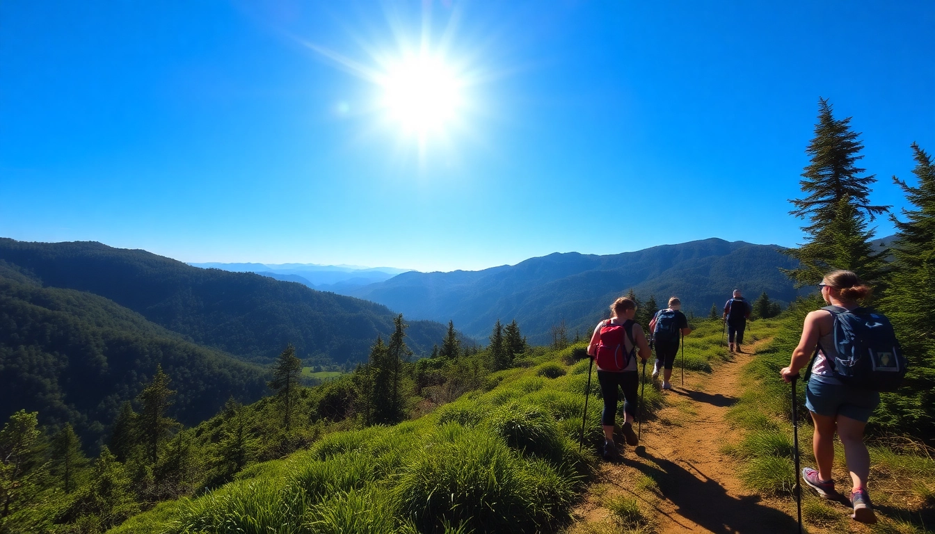
The two primary routes leading to the summit are the Sembalun and Senaru trails, each offering unique experiences and challenges. The Sembalun route, starting from the eastern side, is known for its relatively gentle ascent through grassy plains and volcanic landscape before reaching the crater rim. It is favored for its scenic beauty and easier acclimatization.
The Senaru route, on the northern side, features a steeper climb through lush rainforest, providing a different ecological perspective. It is often the starting point for longer treks and attracts those seeking a more challenging ascent with dramatic views of waterfalls and dense jungle.
Both routes converge near the summit, offering opportunities for shared exploration and breathtaking sunrise views.
Difficulty Levels and Duration of Treks
Offering a range of trekking experiences, Rinjani’s difficulty is classified as moderate to challenging. The typical 3-day/2-night trek is accessible for most fit hikers, covering approximately 27-35 km depending on the route. For experienced trekkers seeking an extended adventure, a 4-day or 5-day circuit allows more time for acclimatization, exploration, and enjoying side trips to waterfalls or hot springs.
Shorter treks, like the 2-day ascent, are possible but often require high fitness levels and quick ascent speeds, which increase risks. The presence of high-altitude conditions, unpredictable weather, and rugged terrain necessitate proper preparation and cautious pacing.
Highlights and Must-See Spots Along Each Route
- Sembalun Route: The grassy plains, sunrise from the crater rim, Lake Segara Anak, hot springs at nearby Senaru valley.
- Senaru Route: Tropical rainforest, waterfalls like Sendang Gile and Tiu Kelep, dense jungle scenery, mesmerizing caldera lakes.
- Summit: The volcanic crater, panoramic views of Lombok, neighboring islands, and the active crater with fumaroles.
Each route offers distinct natural beauty, cultural interactions with local villages, and unforgettable vistas that elevate the Rinjani experience beyond mere trekking.
Challenging Aspects of Climbing Mt. Rinjani and Safety Tips
Dealing with Altitude, Weather, and Terrain Challenges
The high elevation introduces altitude sickness risks, characterized by headache, dizziness, and fatigue. To mitigate this, proper acclimatization days, hydration, and pacing are vital. Watching weather forecasts is critical—sudden storms can reduce visibility, cause hypothermia, or create landslide hazards. Trekkers should be prepared for rapid weather changes with layered clothing and waterproof gear.
The rugged terrain encompasses volcanic scree, rocky paths, and steep inclines. Using trekking poles, wearing sturdy boots, and following designated trails enhance safety and stability.
Rescue Protocols and Emergency Contacts
While emergency response systems are limited in remote mountain areas, local authorities maintain protocols for rescue operations. It is vital to carry a communication device such as a satellite phone or emergency beacon. Guides are trained in basic first aid and evacuation procedures, but trekkers should also familiarize themselves with basic emergency responses.
Always inform someone about your itinerary, expected return time, and have a plan for emergencies. When encountering health issues or accidents, contact local park authorities or rescue teams immediately.
Environmental Conservation and Respectful Tourism Practices
Protecting Rinjani’s fragile ecosystem requires responsible tourism practices. Trekkers should follow Leave No Trace principles—disposing of waste properly, minimizing campfire impact, and respecting wildlife and local communities. Use biodegradable products, avoid touching or removing natural features, and support local businesses to foster sustainable tourism.
Post-trek Adventures and Connecting with Lombok Culture
Local Villages, Traditional Cuisine, and Cultural Experiences
Beyond the mountain, Lombok offers a rich tapestry of cultural experiences. Visiting local villages such as Sembalun or Senaru provides insight into traditional Sasak customs, arts, and crafts. Engaging with local communities fosters meaningful connections and supports sustainable development.
Sampling authentic Sasak cuisine—such as Ayam Taliwang (spicy grilled chicken), plecing kangkung (vegetable salad), or fresh seafood—complements the outdoor adventure. Participating in local ceremonies or traditional markets enriches your understanding of Lombok’s cultural fabric.
Additional Attractions in Lombok and Nearby Islands
After conquering Rinjani, travelers can explore Lombok’s other attractions—such as Gili Islands’ pristine beaches and vibrant nightlife, the waterfalls in North Lombok, or the indigenous Sasak villages. For extended adventures, a boat trip to the nearby Komodo National Park or diving in the Coral Triangle offers memorable marine encounters.
Sharing Your Rinjani Adventure: Social Media and Tips for Future Climbers
Documenting your journey through photography, blogs, or social media inspires future climbers and raises awareness about sustainable tourism. Sharing practical tips like booking guides in advance, packing appropriately, and respecting local customs can help foster a community of responsible explorers. Remember, your experience can motivate others to appreciate and protect this natural wonder.